2022 – NEW REGULATIONS!
Trout Stocking Season
Year-round.
Designated Trout Area/Size/Location
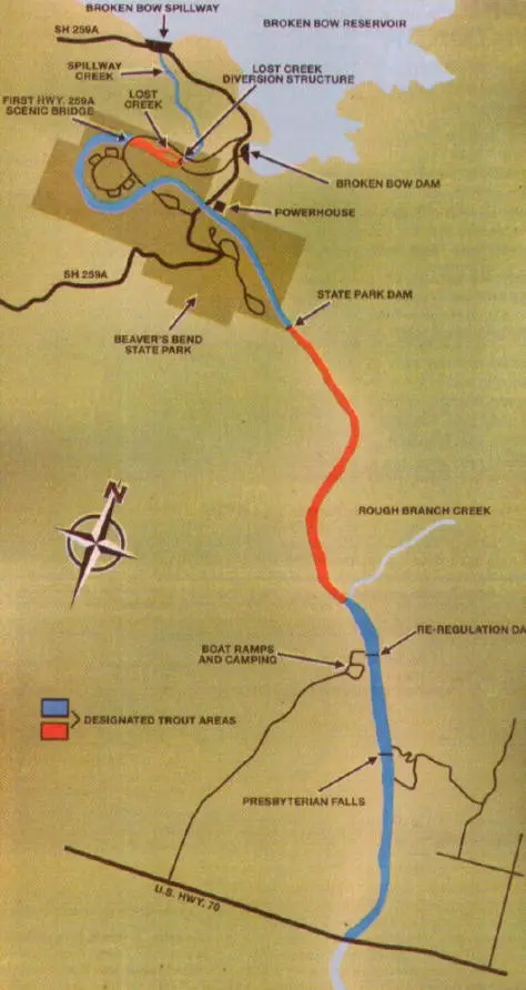
Twelve-mile portion of the Lower Mountain Fork River and its tributaries from the Broken Bow Reservoir Spillway downstream to the U.S. HWY 70 Bridge. About five miles of this designated trout stream lies within Beavers Bend State Park, in McCurtain County.
Bank Access/Boat Ramps
Bank access is unlimited within the state park and downstream to the re-regulation dam. Another public access point exists at Presbyterian Falls. Boat ramps are just upstream of and below the re-regulation dam.
Notes of Interest
Camping and cabin facilities are available within Beavers Bend State Park and below the re-regulation dam. For information, call the park at (580) 494-6300.
Trout Regulations
- BARBLESS HOOKS ONLY
- Use of bait is permitted
Area 1 (from the Broken Bow Reservoir Spillway downstream to the Old State Park Dam.)
- Daily limit: 3 in aggregate, only one of which may be a rainbow trout greater than 25 inches, and only one of which may be a brown trout which must be greater than 30 inches. Counts towards the aggregate limit for the entire Lower Mountain Fork Trout Area.
Area 2 (from the Old State Park Dam downstream to the US 70 HWY bridge.)
- Rainbow Trout Daily limit: 1; must be greater than 25 inches. Counts towards the aggregate limit for the entire Lower Mountain Fork Trout Area.
- Brown Trout Daily limit: 1; must be greater than 30 inches. Counts towards the aggregate limit for the entire Lower Mountain Fork Trout Area.
ANS Alert: Didymo, an aquatic nuisance species commonly referred to as “rock snot,” has been identified in the Lower Mountain Fork River. To prevent spreading this undesirable organism, please clean and dry waders and other fishing equipment after use in the Lower Mountain Fork River.